With the finishing of the Big Dig and the tearing down of the old elevated artery, Boston now has a lot of new open land, both along and near the waterfront. The land along the waterfront can now be enjoyed by taking a stroll on the Boston Harborwalk, with one stretch of the Harborwalk going from South Boston all the way to the tip of Charlestown, with few interruptions.

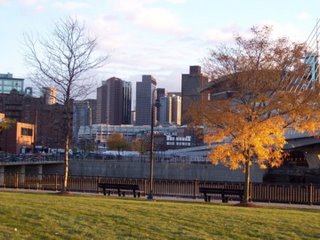
Starting by the Gillette Plant in South Boston, the Harborwalk goes along the east side of the Fort Point Channel, going past South Station and the Boston Children's Museum. The stretch by the museum is particularly scenic, with striking views of the Boston skyline (see photo) as the walkway heads toward the end of the channel. From this point, the Harborwalk winds its way past the wealthy residences of Rowes Wharf and India Wharf. The next stop is the New England Aquarium and Long Wharf, both of which attract crowds of tourists.

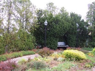
After Long Wharf and Christopher Columbus Park, the Harborwalk meanders up and down various wharves in the North End. One of the most interesting of these is Lewis Wharf, where people can relax at a little-known garden (photo), complete with benches and narrow walkways. This is one of the most peaceful spots along the Harborwalk, and is a beautiful spot during the summer when plants are in full bloom.

From Lewis Wharf, the path continues to wind along a few more wharves in the North End, though many users of the Harborwalk cut through the North End neighborhoods to see some of the interesting restaurants, shops, churches, and other points of interest, eventually meeting up with the Harborwalk near the Charlestown Bridge. From this point, there are a couple of options, one of which is to take a walkway over the Charles River Dam. Some of this walkway includes movable sidewalks over the dam. Now in Charlestown, the walkway emerges from the dam at Paul Revere Park (photo), a small area of open space with memorable views of the Zakim Bridge and the Boston skyline.

Continuing northeast along the water, the Harborwalk cuts past Tudor Wharf, then enters Boston National Historic Park and the Charlestown Naval Shipyard, where the U.S.S. Constitution is located. Going past Shipyard Park, the Harborwalk goes past a few more wharves and some quiet waterfront neighborhoods before coming to an end near Building 114 (photo) in the shadows of the Mystic Tobin Bridge. This vast building was once used for building boats for the navy, and now is a multi-use facility. It is open 24 hours a day, and has rest rooms, vending machines, and chairs and tables where people can relax before heading back along the Harborwalk.
 Starting by the Gillette Plant in South Boston, the Harborwalk goes along the east side of the Fort Point Channel, going past South Station and the Boston Children's Museum. The stretch by the museum is particularly scenic, with striking views of the Boston skyline (see photo) as the walkway heads toward the end of the channel. From this point, the Harborwalk winds its way past the wealthy residences of Rowes Wharf and India Wharf. The next stop is the New England Aquarium and Long Wharf, both of which attract crowds of tourists.
 After Long Wharf and Christopher Columbus Park, the Harborwalk meanders up and down various wharves in the North End. One of the most interesting of these is Lewis Wharf, where people can relax at a little-known garden (photo), complete with benches and narrow walkways. This is one of the most peaceful spots along the Harborwalk, and is a beautiful spot during the summer when plants are in full bloom.
 From Lewis Wharf, the path continues to wind along a few more wharves in the North End, though many users of the Harborwalk cut through the North End neighborhoods to see some of the interesting restaurants, shops, churches, and other points of interest, eventually meeting up with the Harborwalk near the Charlestown Bridge. From this point, there are a couple of options, one of which is to take a walkway over the Charles River Dam. Some of this walkway includes movable sidewalks over the dam. Now in Charlestown, the walkway emerges from the dam at Paul Revere Park (photo), a small area of open space with memorable views of the Zakim Bridge and the Boston skyline.
 Continuing northeast along the water, the Harborwalk cuts past Tudor Wharf, then enters Boston National Historic Park and the Charlestown Naval Shipyard, where the U.S.S. Constitution is located. Going past Shipyard Park, the Harborwalk goes past a few more wharves and some quiet waterfront neighborhoods before coming to an end near Building 114 (photo) in the shadows of the Mystic Tobin Bridge. This vast building was once used for building boats for the navy, and now is a multi-use facility. It is open 24 hours a day, and has rest rooms, vending machines, and chairs and tables where people can relax before heading back along the Harborwalk.